GeoMonday the 4th – Developing location based apps for Gear; challenges and lesson learned

Gear_S_front_black_5
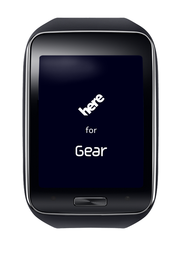
Motorola, LG, Samsung, Sony, TomTom, Garmin, Apple and few more companies have recently launched or announced connected or smart watches.  While some people are still challenging the user benefits of a connected watch,  let ‘s look at the developer opportunities and challenges to deliver Location Services to a wearable with the example of the  “Navigator” app developed by HERE for the new Samsung Gear S.

TamerTamer Nassif is Senior Software Engineering Manager at HERE, a Nokia company and leading, building Local/international engineering teams (up to HC of 25) within North America, Europe and Asia. Working closely with customers, engineering, sales, and product owners, marketing and human factors (UX) to conceive, plan, design, develop, and deliver mobile/embedded and client/server software consumer product. He worked for and with the world’s top mobile handset OEM‘s and chipset makers. Delivered successfully on broad spectrum of software programs, products and services ranging from low tier (Emerging markets) to high tier (smartphones) products and consumer devices. Motorola RAZOR, Q9, CN620, DROID, BB Z10, BB 8920, Samsung Redwood Tizen, Gear S are examples of such products I worked or currently working on

Get in contact via mail or connect with him on Google+ or Linkedin.

Esri is official sponsor of GeoMonday the 4th

The GeoMonday team wanna thank a lot Esri Deutschland for sponsoring our 4th edition all around Location and Internet of Things. Here a nice quote from the team:

Esri_Logo_US_Deutschland_RGB

For spatial analysis, planning and decision-making, the geo information solutions based on Esri’s ArcGIS platform are the first choice in the private and public sectors as well as education and science. Adaptable and intuitive with integration options, industry standard ArcGIS can be used on mobile devices, desktops and servers and is highly appreciated by more than one million users worldwide.


As a distributor and systems house, Esri Deutschland GmbH, member of the Esri Deutschland Group GmbH, based in Kranzberg near Munich, sells the products of Esri Inc. on an exclusive basis at eleven locations in Germany and Switzerland. Esri provides support to users with a wide range of training, support and consultancy backed by combined experience and expertise of over 500 employees in the Esri Group.
Headquartered in Redlands, California (USA), Esri Inc. is a pioneer in the field of professional geo information solutions and the development of a modern understanding of the environment and its geographical, cultural and economic connections.


GeoMonday the 4th – Carspotting: Vimcar turns car data into hard cash for its users

Vimcar
 
Vimcar leverages car data collected via onboard diagnostic ports. They use a tiny dongle which comes ready with GSM card and GPS sensor. Learn how the proof-of-concept product took shape and where Vimcar is headed next.
 
 
Malte Windwehr is Head of Marketing at Vimcar. Before that, he worked on communication strategies for SMEs in Germany and produced content for Condé Nast Digital, Deutsche Bank and several startups in Berlin. Malte learned his trade at Scholz & Friends Hamburg, Saatchi & Saatchi Frankfurt and Avantgarde New Delhi.
 
 
Follow their blog at: http://blog.vimcar.de/ or at Twitter: @goVimcar


GeoMonday the 4th – Multiplayer Tracking on Multiple Devices

lena ad 600Dustcloud is an Urban Game game for mobile devices and wearable computing, played with GPS Tracking and Bluetooth-enabled smart guns, called Dusters. We built the base game in Prague in 2011, took it to Berlin in 2013, and spent the last half of 2013 in China, learning the ins and outs of hardware manufacturing. Presently, we’re beta testing our mobile apps and database, and have discovered a whole lot of problems generated by the human element of turning our game over to players, and watching them play the game remotely, without our supervision. Murphy’s Law definitely applies – whatever can go wrong, will, and usually does. The talk will cover programming for Android and iOS devices, developing for Google Maps, vs OpenStreetmap, and building UX/UI for multiple players.

H Agent 5

Howard Hunt is the Founder/CEO of Dustcloud. He builds expensive looking things for not much money. Here is his blog: http://blog.thedustcloud.com / This is him on Google Plus: http://bit.ly/1vSXzy2  / And LinkedIn: http://linkd.in/1qkqdWV ? And demoing a headset game in the Berlinerstrasse S-Bahn: https://vimeo.com/100100149

GeoMonday the 4th – Location & Internet of Things (IoT)

geomonday_4

GeoMonday the 4th – Location & Internet of Things (IoT)

Intro

The world around us gets even smarter and more and connected every day. Beside keys, bikes or watches there are also other form factors taking presence in the Internet. With the growing number of location aware devices and sensors, there is a huge opportunity for an entire new set of services and applications. Therefore we will focus in our 4th edition around “Location and Internet of Things”.

Bear with us, as we will announce our really great speakers over the next weeks.


Agenda

When: Monday, September the 22nd, 2014. Presentation will start at 7pm

Where: Mobilesuite, Pappelallee 78/79, 10437 Berlin


Speakers

Howard Hunt (Dustcloud) – Multiplayer Tracking on Multiple Devices

Malte Windwehr (Vimcar) – Carspotting: Vimcar turns car data into hard cash for its users


You’re interested or already dealing with that topic? Join our event and get your free or premium tickets here: geomonday4.eventbrite.com

PS: If you want to present your Location and IoT story, please contact us at info@geomonday.org and provide your headline and some background information.