GeoMonday 2015.3 – Impressions

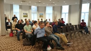
Hosted at the scenic location in the center of Potsdam, close to the river Havel, this 3rd GeoMonday turned out to be a really nice occasion for all drone enthusiasts. Our first outdoor hands on session was blessed with rays of sunlight from a Indian summer sun.

Thanks again to the interested audience and to all of our fantastic speakers.


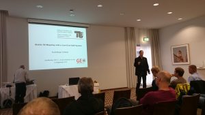
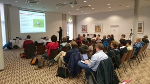
The session was kicked-off with the live data collection session using a smart drone, presented by Arno Fischer,  professor at the University of Applied Sciences Brandenburg.

Here is the spectacular video from our session ground:

[slideshare id=53239265&doc=fhbgeomonday-2015-potsdam-150927082750-lva1-app6891]


Immediately afterwards Frank Neitzel, professor at the Technical University (TU) Berlin, told us how to build a drone from very affordable components and get the system working.


Our third speaker of the evening was Martin Scholl. In his presentation he gave insights of a project equal to OpenStreetMap, the OpenAerialMap in order to create aerial views of the world:

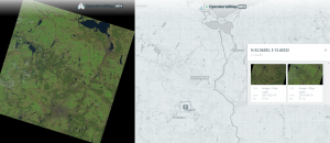
[slideshare id=52780124&doc=201509geomonday2-150915020313-lva1-app6892]


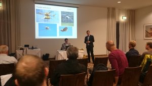
The closing session was held by Christian Janke, Research Engineer at the European Aviation Security
Center (EASC)
 in Germany. He spoke about the chances and challenges of unmanned aviation.

[slideshare id=53238892&doc=cjgeomonday140915short-150927080011-lva1-app6891]


GeoMonday 2015.3 – Speakers, venue and transport information

As our next event at the 14th of September is soon to kick-off, here for your the complete list of speakers for GeoMonday 2015.3 – A new dimension in Geo:

Martin Scholl: Capturing the world in 3D: beyond OpenStreetMap
Christian Janke: Chances & challenges of unmanned aviation
Frank Neitzel: Mobile 3D Mapping with a Low-Cost UAV System
Arno Fischer: A practical guide to use drones

Please remember we start this time at 6PM, as we planned for a live hands-on session into unmanned aerial vehicles (UAVs) before the talks will start. Also this time we enjoy to have our event in the wonderful city of Potsdam, located south-west at the gates of Berlin. The address is:

arcona Hotel am Havelufer
Zeppelinstraße 136
14471 Potsdam

A possible route is available here:

https://www.google.com/maps/dir/Mitte/arcona+Hotel+am+Havelufer,+Zeppelinstraße+136,+14471+Potsdam/@52.4610203,13.1363902,12z/data=!3m1!4b1!4m18!4m17!1m5!1m1!1s0x47a851dd8abc4201:0x52120465b5fabc0!2m2!1d13.3830683!2d52.5306438!1m5!1m1!1s0x47a8f4357f4f7fa1:0x3953a63584cb8ac7!2m2!1d13.0335271!2d52.3907463!2m3!6e0!7e2!8j1444842000!3e3

For those who haven’t got there free tickets yet, here is your link:

https://geomonday2015-3.eventbrite.de

GeoMonday 2015.3 – A practical guide to use drones

fhb_logo_neuIn this presentation it is shown a complete workflow for 3D-Reconstruction using a civil drone and getting structure-from-motion (SFM) technologies. Security issues and legal aspects are also considered.

The following questions and actions are discussed and
performed:

  • what is the minimum set for a drone mission (Hardware and Software Requirements)
  • basics for flying a drone, Safety and Security and legal aspects
  • basics to prepare an autonomous flight
  • concrete steps to prepare and fly the mission
  • how to process the data (image data)
    • e.g. how to get still images from a video stream and more
  • practical aspects about photogrammetry, especially stereo photogrammetry
  • define the workflow for 3D reconstruction using commercial software.

Fischer-mit-Drohne
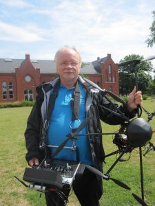
Arno Fischer is a Professor for Operating Systems and Computer Networks at the University of Applied Sciences Brandenburg (FHB). He has been working on drone technologies: Anticollision Systems (Detect and Avoid), Attitude Control, Safety and Security for Drones, Civil Applications and Use Cases with Drones and Teaching Concepts. On Behalf of FHB he is member of UAV-DACH and DIN (NA 131-01-01 AA Arbeitsausschuss Unbemannte Luftfahrtsysteme).

GeoMonday 2015.3 – Mobile 3D Mapping with a Low-Cost UAV System

TU_Logo_lang_RGB_rotIn this presentation it is shown how an UAV system can be built at low costs. The components of the system, the equipment as well as the control software are presented. The main focus of this presentation is on the generation of 3D point clouds from digital imagery. For this web services and free software solutions are presented which automatically generate 3D point clouds from arbitrary image configurations. Possibilities of georeferencing are described whereas the achieved accuracy has been determined. The presented workflow is finally used for the acquisition of 3D geodata. On the example of a landfill survey it is shown that marketable products can be derived using a low-cost UAV. At the end of the presentation the latest trends in the UAV market are presented.

Neitzel
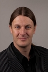
Frank Neitzel is a Professor for Geo-IT and Geodesy at the Technical University (TU) Berlin. He has a lot of experience in building affordable drones for 3D Geo-data collection and already published related papers.

GeoMonday 2015.3 – Chances & challenges of unmanned aviation


Chances:
The drone industry is diverse, innovative and international. It has an enormous potential for growth with the associated possibility to create jobs.  Today there is a fast-developing community that uses Unmanned Systems in general or RPAS in specific, for multiple applications. Some examples are: precision agriculture, infrastructure inspection, wind energy monitoring, pipeline and power inspection, highway monitoring, natural resources monitoring, environmental compliance checking, atmospheric research, media and entertainment, sporting event photography, filming, wildlife protection and research, hunting and anti-hunting monitoring and disaster relief (EASA CONOPS, 2015).In EASA countries there are 2495 operators and 114 RPAS manufacturers. They produce and operate RPAS from very small to medium sizes with a maximum take-off mass (MTOM) below 150kg (EASA CONOPS, 2015).
Worldwide there are different levels of freedom for UAS/RPAS, ranging from complete prohibition to full integration in low-airspace beyond-visual-line-of-sight.

Challenges:
Due to recent reports about different events, the topic of civil use and misuse of unmanned aircraft systems (UAS) is gaining attention. Other terms are „RPAS” – Remotely Piloted Aircraft Systems or plainly “drones”.Especially small UAS (sUAS) are easy to obtain (self-made or purchase), easy to operate and very mobile (vehicle and remote control are portable). sUAS can be fixed-wing, quad-or multicopter, propelled by electric or piston engine and piloted remotely or automatically.Furthermore sUAS are difficult to detect and counteract. Performance and payload capabilities of modern sUAS are raising the question of a possible misuse.
Current and present examples are various, from the disruption of international soccer games, secret observation of French nuclear power plants, smuggling of contraband into prisons to the increasing use of UAS for espionage and intrusion of privacy.
Possible threat scenarios show even more hazardous possibilities of unlawful interference through crime and terrorism. Equipped with a respective payload sUAS can travel the appropriate distance to enter secured areas or perimeters. In this domain of Safety and Security considerations, it is necessary to focus on feasible detection methods against misuse or adversary UAS.

Christian Janke is currently a Research Engineer at the European Aviation Security unnamedCenter
 (EASC) in Germany. His R&D focus is on Unmanned Aircraft Systems, technology impact assessment in context of legal frameworks and stakeholders. He is currently promoting Unmanned Aviation, like UAV DACH and UVS International in close cooperation with national and international associations. Aim of this engagement is facilitating broad civilian UAS applications by addressing questions like weight classes, visibility minima or insurance context.

GeoMonday 2015.3 – Capturing the world in 3D: beyond OpenStreetMap

OpenAerialMap, OpenDroneMap, OpenUAV – there are plenty of new projects around the idea of leveraging UAVs and digital cameras as a map data source. They are all following OpenStreetMap’s idea of creating a new map data source that is open. The talk will give an overview of the OpenAerialMap initiative and how to use the OpenDroneMap (ODM) software package to create 3D models and ortho-images. Some thoughts about the meaning and future of ubiquitous UAV technology for data capturing and surveying will aMartin_Scholl_1 smalllso be presented.

Martin Scholl is a software engineer and 3 times company founder. His current focus is 3D digital perception and digitalization with applications in robots, autonomous systems, and art marketing.

GeoMonday 2015.3 – A new dimension in Geo

Intro

One of the most discussed topic of the recent years is the rise of UAVs, MAVs, RPVs or simply drones. These flying devices are equipped in their latest evolutions not only with full HD cameras, but also GPS devices and even small computers. This equipment is the base for next generation aerial geo-data and services. In the 3rd edition of GeoMonday we will cover the whole lifecycle from the creation, processing up to the integration for location intelligence or services. It’s a special pleasure for us to have our session for the first time in the beautiful city center of Potsdam, thanks to our Partner Zukunftsagentur Brandenburg.

Agenda:

When: Monday September 14th, 2015, starting 6pm sharp
Where: arcona Hotel am Havelufer, Zeppelinstraße 136, 14471 Potsdam

You are welcome to join our event to become part of the GeoMonday community. Get your free tickets here:
https://geomonday2015-3.eventbrite.de

We will announce our speakers in the next days and weeks, so stay tuned…

GeoMonday 2015.2 – Impressions

The second session of GeoMonday featured some amazing talks, all around services and applications that will improve the life of urban people significantly. Thanks goes to our always interested audience and to the great set of speakers:

  • Urs Fischer from ParkU demonstrated how their system helps better managing urban parking space demand
  • Christian Maertins from HaCon showcased how Beacons could be an opportunity for indoor navigation in public transportations
  • Sebastian Heise from graphmasters gave us good insights into smart traffic management
  • Henning Hollberg from Motion Intelligence presented their technology Route360°

We hope everyone of you had a great time. Below you find some impressions of our session. We hope to see you at our next event, September the 14th, in Potsdam.


GeoMonday 2015.2 – Indoor Navigation for Public Transport: The Beacon Opportunity

hacon-logo Headquartered in Hannover, Germany, HaCon creates and develops high-quality software solutions for traffic, transport and logistics. With over 30 years of experience and a dedicated team of 240+ IT and transport planning specialists, HaCon has established itself as a leading European player for planning, scheduling and information solutions.

The timetable information system HAFAS is used by transportation companies and networks all over the world. Every day, passengers in more than 25 countries place over 40 million journey planner requests that facilitate the use of public transport. Long-time HAFAS customers such as Deutsche Bahn (Germany) and SNCF (France) benefit from ever new, innovative developments for mobile applications, internet journey planners and printed timetables.

A powerful solution for train planning and capacity management, HaCon’s TPS software enjoys a growing European user base.

Christian MaertinsChristian Maertins works since of the 1990s as Carsharing, Ridesharing, eTicketing, network electric mobility consultant. 2011 he founded a StartUp to develop a multimodal Application. This app is integrated since 2014 to HaCon on Mobility Lab.

GeoMonday 2015.2 – Route360°

MI_logoThe idea of Motion Intelligence and its technology Route360° is to simplify the online search for spatial objects (local search) by the use of sophisticated route planning and travel time analysis and visualization.

Motion Intelligence provides the Technology to third party institutions and companies. Additionally Motion Intelligence offers to create concepts, develop and run applications, extend existing applications or create new ones from scratch. Motion Intelligence is specialized in travel time analysis and visualization in order to help people finding or evaluating spatial objects.

foto

Henning studied Cartography and Geomatics in Karlsruhe from 2006 until 2010 and finished with a bachelor’s degree. Since 2010 he was studying Geoinformation and Visualization at Potsdam University and received his masters degree in 2014.

In his studies he focused on the analysis of large traffic networks. The final thesis “Interaktive Analyse und Visualisierung der Erreichbarkeit in Verkehrsnetzen“ was supervised by the Institute of Geography and the Hasso-Plattner-Institut (HPI).

It recieved a lot of positive feedback and is the basis of the startup Motion Intelligence.